
City Market
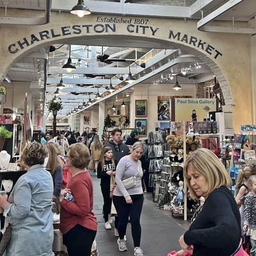
The City Market is a famous Charleston landmark and a favorite of visitors. Encompassing four city blocks from Meeting to East Bay Streets, the City Market houses is known for Sweetgrass baskets, tremendous restaurants, bars, local vendors selling everything from jewelery to novelty items and is where the immensely popular carriage tours depart from.
Market Hall Painstakingly restored, this Roman Revival building soars as majestically above Charleston’s tourism trade as it once did over the beef market that occupied the block behind it. While most of the building is brick covered with rouge-tinted stucco (colored in some areas with pigmented lime wash), it also has brownstone details and bronze ornaments in the frieze depicting the skulls of rams and oxen, the use of which to indicate proximity to a meat market has precedence in Roman architecture.
During the Civil War, the upper floor was used as a venue for balls to support the Confederate cause and is today leased by the Daughters of the Confederacy where a museum is housed. The legendary Palmetto Guard was honored here before going to war, and the veterans gathered here annually to remember their fallen comrades through 1917, when the last two survivors met.
City Market Where the City Market now stands was originally a tidal creek that ran just north of the walled Colonial city of Charles Towne. The creek was filled in and the land donated to the city for the placement of an open-air food market, a purpose the present buildings served from 1804 until the early 20th century. Victorian era photographs show basket-toting women in the streets at the Beef Market, dodging turkey buzzards (euphemistically referred to in contemporary accounts as “Charleston eagles”), which kept the area clean.
Among the vendors who now occupy the Market are ladies demonstrating the originally African craft of sweetgrass basketry, the most visible vestige of Gullah culture. The word “Gullah” likely originated from the word “Angola”, which in the early 18th-century referred to the region generally south of the Congo River from which most slaves were brought. By mid-century, Planters were showing a distinct preference for Slaves from the coastal areas above the Congo, where rice was a major crop and methods from those areas were being employed in the Lowcountry rice industry. Baskets like these were used for winnowing – tossing the pounded grains through the air to let the breeze carry away the chaff – and virtually identical baskets found in Senegal Africa were used there for the same purpose.
The Battery & Whitepoint Gardens
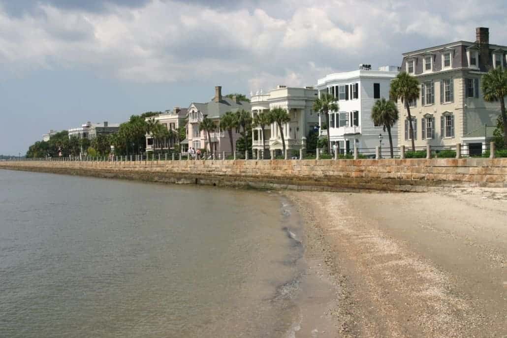
Named for a civil-war coastal defense artillery battery at the site, it stretches along the lower shores of the Charleston peninsula, bordered by the Ashley and Cooper Rivers, which meet here to form Charleston harbor. Historically, it has been understood to extend from the beginning of the seawall at the site of the former Omar Shrine Temple (40-44 East Bay Street) to the intersection of what is now Murray Boulevard and King Street. The higher part of the promenade, paralleling East Battery, as the street is known south of Water Street, to the intersection of Murray Boulevard, is known as High Battery. Fort Sumter is visible from the Cooper River side (High Battery) and the point, as is Castle Pinckney, the World War II aircraft carrier USS Yorktown (CV-10), Fort Moultrie, and Sullivan’s Island.
Fort Broughton (ca. 1735) and Fort Wilkins (during the American Revolution and War of 1812) occupied White or Oyster Point, so named because of the piles of bleached oyster shells on the point at the tip of the peninsula. In the 18th century, rocks and heavy materials were used to fortify the shore of the Cooper River on the eastern side of the peninsula. In 1838, this area of the Battery, known as High Battery, became a promenade. First used as a public park in 1837, the area now known as White Point Garden became a place for artillery during the American Civil War.
In popular speech and in a number of unofficial guidebooks and Web sites, The Battery and White Point Garden are sometimes referred to as “Battery Park,” but the park and seawall promenade are not regarded by the City of Charleston as a single entity, and the term “Battery Park” is not an official designation.
In 2004, a structural report by the City of Charleston showed that the Battery was suffering serious problems and could fail to protect the southeastern portion of the city during hurricanes. In 2012, the City announced that a $3.2 million restoration project would soon commence at the conjure of High Battery (along East Battery) and Low Battery (along Murray Blvd.).
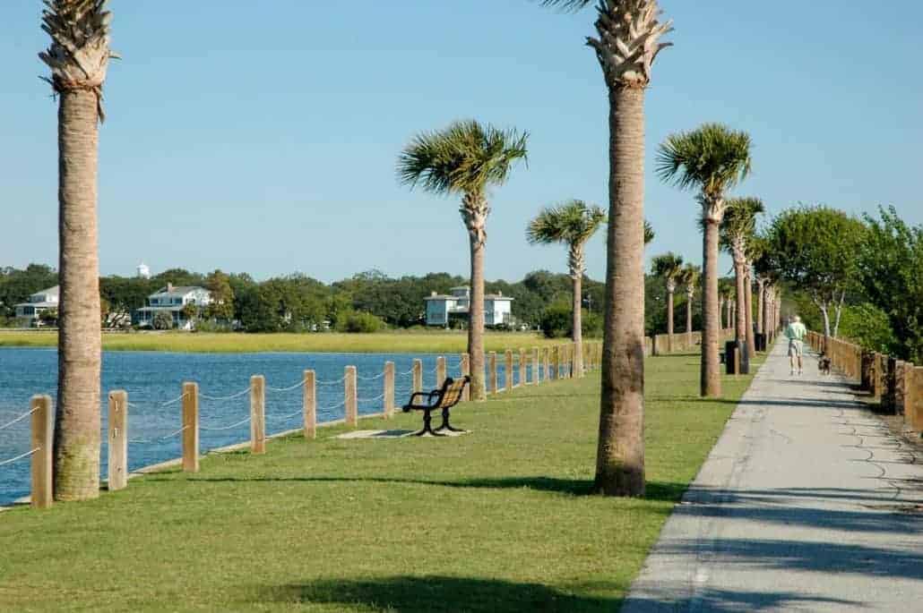
Sullivan’s Island

The Town of Sullivans Island, a barrier island north of the Charleston harbor, has only about 2,000 residents. With its unspoiled views and terrific dining options, Sullivans is a favorite among Charleston area locals. The beach has few short-term rentals and no hotels so plan a day trip to this beach, also located just a few minutes from the Isle of Palms.
Where to park: Parking can be a problem if you arrive after 10 a.m. There are no public parking lots, and street parking is allowed on one side of the street only. Be sure to obey posted signs and do not park in any private yards or driveways.
Poes Tavern on Sullivans Island Lunch break: Poes Tavern, 2210 Middle St., is named for Edgar Allan Poe, who, at the age of 18, enlisted in the Army and was stationed at Fort Moultrie. A favorite among locals and visitors, Poes menu is filled with gourmet burgers (try the Black Cat with grilled onions, chili, bacon and pimento cheese) and fish tacos (order the citrus-marinated mahi-mahi).
Beach beers: Dunleavys Pub, 2213 Middle St., is a family owned Irish pub with a long history on the island. Unwind with a cold beer after a long, hot day on the beach.
Dinner by the ocean: The Obstinate Daughter, 2063 Middle St., is a southern restaurant with Spanish, Italian and French influences. The menu is packed with small plates, pasta and gourmet pizzas. Try the Lowcountry shrimp roll or butterbean ravioli topped off with a glass of wine.
Sullivans Island Best selfie spot: Built in 1962, the modern-looking Sullivans Island Lighthouse sits just off the shore adjacent to Fort Moultrie. Access is via Station 18 1/2.
Rules to know: Sullivans Island has no public restrooms or showers and there are no lifeguards on duty. Alcohol is not permitted on the beach. All dogs visiting the island must have a dog permit and should wear the town-issued collar while on Sullivans Island. Permits and collars are available at Town Hall, 2050-B Middle St. 843-883-3198. Dogs are not allowed on the beach during certain times in the summer season. More info and complete beach rules: https://sullivansisland-sc.com
Sullivans Island fun fact: This Island has a long military history of protecting the Charleston harbor from invaders. Visit Fort Moultrie, originally built with palmetto logs in 1776, to how it has been restored to reflect the story of American seacoast defense up through World War II.
St. Phillips Church & Graveyard

Building and graveyard are open to the public Mon-Fri 10am to 12pm and 2pm to 4pm.
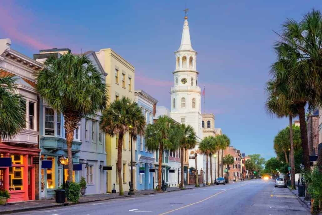
Established in 1681, St. Philip’s is the oldest religious congregation in South Carolina. The first St. Philip’s Church, a wooden building, was built between 1680 and 1681 at the corner of Broad and Meeting streets on the present day site of St. Michael’s Episcopal Church. It was damaged in a hurricane in 1710 and a new St. Phillip’s Church was begun a few blocks away on Church Street. After being delayed it was finished in 1723 but burned to the ground in 1835. Work on the present church was begun that same year and completed the next. The steeple was added between 1848 and 1850.
Many prominent people are buried in the graveyard, which is divided into two parts. The western yard was initially set aside for the burial of “strangers and transient white persons,” but church members were later buried there. Several colonial Governors and five Episcopal bishops are buried here, as well as John C. Calhoun (former Vice President of the United States), Rawlins Lowndes (President of South Carolina in 1778-79), and Dubose Heyward (author and playwright).
The view of Church Street punctuated by St. Philip’s remains one of Charleston’s most photographed spots.
St. Michael’s Church & Graveyard
If the doors are open you are able to step inside and visit the church.
St. Michaels Church is the oldest church edifice in the City of Charleston, standing on the site of the first Anglican Church built south of Virginia.
In 1680 a small wooden church, the first in the new town of Charles Town, was built on this spot for the families of the Church of England, and named St. Philips. By 1727, the town had grown too large for the small church and a more spacious one was built of brick on Church Street, later destroyed by fire in 1835. By 1751, St. Philips had again proved too small for the increasing population, and another church as authorized by the General Assembly of the Province, to be built on the old site and to be known as St. Michael’s. The cornerstone was laid in 1752 and in 1761 the church was opened for services. Except for the addition of the sacristy in 1883 on the southeast corner, the structure of the building has been little changed.
The large, long double-pew in the center of the church, No. 43, originally known as “The Governors Pew, is the one in which President George Washington worshiped on Sunday afternoon, May 8, 1791. General Robert E. Lee also worshiped in the pew some seventy years later. The pews, of native cedar, are very much the same as they have always been except for the addition of ten, filling up what was once an aisle from the south door to a north door (now filled by the “Annunciation” window), thus originally making a cruciform design with the main (east-west) aisle.
John Rutledge, the first Governor of SC, signer of the Declaration of Independence and US Constitution is buried in the graveyard here.
SC Historical Society Museum
Immerse yourself in the history of South Carolina!
Although founded in 1855 as an archive and private manuscript repository, the South Carolina Historical Society opened its first museum open to the public in September 2018. The new space pairs personal manuscripts, maps, and artifacts with innovative technology as visitors experience illuminating moments in our past.
The newly remodeled, repurposed Fireproof Building is the home of the Historical Society headquarters. The National Historic Landmark houses a new, state-of-the art museum with interactive exhibits that showcase South Carolina history, culture, and arts. Designed by Robert Mills and constructed between 1822 and 1827, the Fireproof Building is believed to be the first of its kind constructed in the United States.
Highlights:
- Informational exhibits.
- Self guided tours.
- Wheelchair accessible.
The museum is closed Easter Sunday, Thanksgiving, Christmas Eve, New Year’s Eve and New Year’s Day.
Riley Waterfront Park & Pineapple Fountain
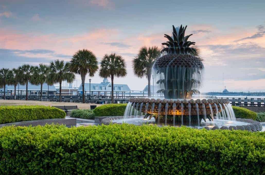
The Charleston Water Taxi departs from the dock here! Relax on the large dock swings, see dolphins in the harbor play, admire the amazing view of the Charleston harbor and get a photo by the iconic Pineapple Fountain.
The park received the 2007 Landmark Award from the American Society of Landscape Architects and the National Trust for Historic Preservation. This award “recognizes a distinguished landscape architecture project completed between 15 and 50 years ago that retains its original design integrity and contributes significantly to the public realm of the community in which it is located.”
The location of the park, between Vendue Range to the north and Adger’s Wharf to the south, had historically been a center of maritime traffic with several wharfs and shipping terminals. The area entered a long period of decline, capped in June 1955 by a fire at a steamship terminal at the site.
By 1980, the site was an “overgrown area marred by charred pilings and gravel parking lots.” Mayor Joseph P. Riley, Jr. began making plans for a park on the site soon after taking office in 1975 after whom the park is named.
Rainbow Row
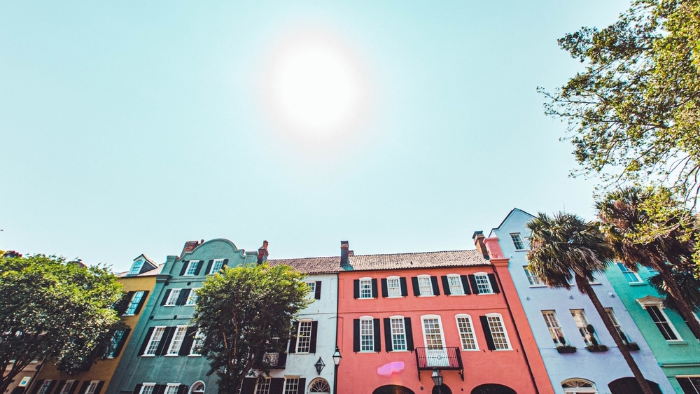
Rainbow Row is the name for a series of colorful historic houses in Charleston, South Carolina. The houses are located north of Tradd St. and south of Elliot St. on East Bay Street.
It is referred to as Rainbow Row for the pastel colors used to paint all of the houses. It is a common tourist attraction and is one of the most photographed parts of Charleston.
After the Civil War, this area of Charleston devolved into near slum conditions. In the early 1900s, Dorothy Porcher Legge purchased a section of these houses numbering 99 through 101 East Bay and began to renovate them. She chose to paint these houses pink based on a colonial Caribbean color scheme. Other owners and future owners followed suit, creating the “rainbow” of pastel colors present today. The coloring of the houses helped keep the houses cool inside as well as give the area its name.
Common myths concerning Charleston include variants on the reasons for the paint colors. According to some tales, the houses were painted in the various colors such that the intoxicated sailors coming in from port could remember which houses they were to bunk in. In other versions, the colors of the buildings date from their use as stores; the colors were used so that owners could tell illiterate slaves which building to go to for shopping.
Pounce Cat Cafe
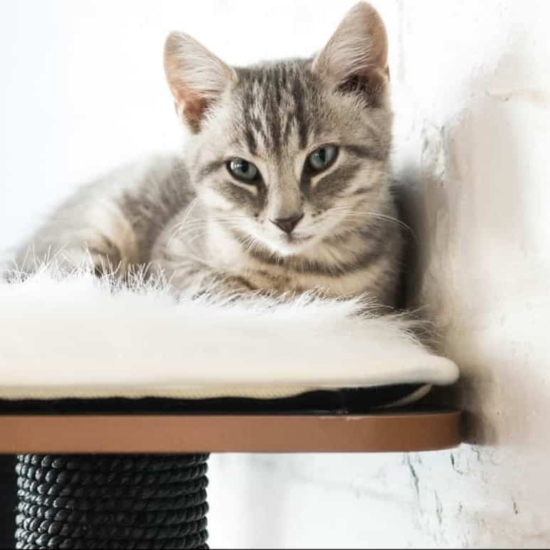
Children under the age of 12 are not allowed. If your group has 8 or more people please call ahead.
What you receive: 1 hour at the Cat Cafe along with one non-alcoholic beverage per person.
Pounce Cat Cafe is a place where you can come to enjoy freshly brewed coffee or tea, sip on wine or craft beer, snack on delicious pastries, and cuddle with adorable (and adoptable!) cats. We’ve teamed up with our local shelter, Charleston Animal Society, to provide our cats, so if at the end of your visit you’ve fallen in love with your new feline friend, you can take them home with you!
Visits to the cafe are $15 per person and include 1 hour in the cat lounge as well as 1 non-alcoholic beverage of your choice to enjoy while you hang out with the kitties. Beverages included with the reservation fee: bottomless non-alcoholic beverages such as coffee, tea, lemonade, and soda. For an additional fee we have wine and beer available. Fresh, local pastries are also available for purchase at the cafe if you would like a snack. Additional time can be purchased at the cafe if the cat lounge is not fully booked for the next hour.
AGE RESTRICTIONS// The minimum age for visiting Pounce Cat Cafe + Wine Bar is 12 years old. A parent or guardian will need to sign a minor waiver for anyone visiting the cafe between the ages of 12 and 17.
CHANGES/CANCELLATIONS: You can alter your reservation date/time by clicking on “Modify Reservation” link in your confirmation email up to 24 hours prior to your visit. You can cancel your reservation up to 24 hours in advance for a full refund.
MAXIMUM GROUP SIZE: Parties larger than 8 people are required to reserve the space as a private event. Not only can large groups be loud and distressing for our cats, they can also be disturbing for other guests who are visiting the cafe during the same hour.
Pitt Street Bridge
An amazing locale to see the Charleston Harbor and view evening sunsets
A bridge at the end of Pitt Street used to span Cove Inlet to connect Mount Pleasant to Sullivan’s Island. When the newer Ben Sawyer Bridge was constructed, the bridge was no longer used. The city renovated the bridge remains by creating a pedestrian greenway with sodded grass and palmetto trees. The bridge extends to roughly 1/2 of the original length, giving visitors a nice view of the surrounding intracoastal waterway. Locals walk, jog, and fish along the bridge. At the end of the walkway, you can see the remains of the old bridge as it extends toward Sullivan’s Island.
